This has given me the courage of conviction to state
what no one dares to say – that the recently reported observation of the solid
inner core of the earth slowing down its motion and now starting to rotate in a
direction opposite to that of the motion of the spinning earth is due to the
earth – along with the entire solar system – moving in a curve in the wavy path
of the sun such that by the year 2300 CE, the observer on earth will start
seeing the equinox moving in the forward (opposite) direction.
This motion on one direction at a time lasts for 3600
years. In the next 3600 years the direction of motion of the equinox changes to
the opposite. The Vedic society had lived long – at least beyond 3600 years to
see the change in the direction of the equinox. In contrast, modern science had
taken into account the precession value given by Hipparchus who lived only 2000
years ago after the Sun had entered the current precession path.
The sixty times the sixty-year cycle (making up 3600
years) that westerners generally attribute to Sumerians is in fact a creation
of the Vedic society which continues to follow the 60-year cycle till this date
and has it well entrenched in thousands of inscriptions of over two millennia found
in the country. The 3600-year duration is applied in two ways – one, for the
entire path of the equinox on one direction and two, from the mid-point of the
path in one direction to the mid-point of the path in opposite direction. To
understand this, let me state the salient features of this to and fro
oscillation theory.
·
The equinox takes
7200 years to complete one round of to-and-fro motion, observed from the earth
as linear movement for 54° on either direction.
·
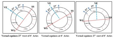
It moves forward
(eastward) for 3600 years and backward (westward) for 3600 years (Fig 1).
·
The mid-point of
the path falls at 0° sidereal Aries. (All locations are expressed for sidereal
positions)

Fig 1: Forward and backward
motion of the equinox
The
rate of the movement of the equinox is expressed in the ancient astronomy texts
as the number of these cycles in a Catur Maha Yuga (4,320,000 years).[i]
The average rate is 600 revolutions in a Catur Maha Yuga that is worked out as
follows:
1
revolution = 27 x 4 = 108˚
600
revolutions = 108 x 600 = 64,800˚
64,800˚
= 43, 20,000 years
Therefore
1˚ = 66.66 years
This
is equal to 54 arc seconds per year.
The
changing rates found in the available astronomy texts of India in the last 1000
years are tabulated in Fig 2.

Fig 2: Changing rate of precession
The
last row is worked out for the current rate of precession to derive the
duration of a revolution. The duration can be seen to hover around 7,200 years
per cycle for all the rates of precession. Consequent to the movement of the
vernal equinox (VE), the winter solstice (WS) and the summer solstice (SS) also
move up to 27˚ on either side of 0˚ Capricorn and 0˚ Cancer respectively
(Fig 3). With the current movement of the WS to the west of Capricorn, the
Vedic society retained 0˚ Capricorn as the WS. The sun at 0˚ Aries is treated
as the VE in South India even today.
The limited movement of the equinox on either side of zero sidereal Aries ensures that there is no major shift in the seasons. With a gradual deviation of only 27˚ in 3600 years (mid-point to mid-point), there is either an early or late onset of spring, with subsequent seasons swaying accordingly. Never can there be a complete displacement of a season in this model.
In tune with the swaying of the equinoxes, the solstices also oscillate, which resembles the sway of the two pans of a Balance. This has prompted the ancestral people to name the base constellation as ‘Tulā’ (balance) in Sanskrit. It is Libra after the Latin word for libration. The equinoctial balance can never be at rest and the solstices can never go beyond a point (Fig 4).

Fig. 4: The horoscopy design of the zodiac
used in India with a Balance marked on it
This limited movement shifts the polar orientation only within 54°. It covers the span of Ursa Minor in the north when checked in the Stellarium simulator (Fig 5).

Fig. 5: Polar shift within the span of Ursa
Minor
With the earth’s axis oriented towards Polaris
at one end at present, a turn-around is imminent as per this to-and-fro concept
(Fig 6).

Fig 6: The earth’s axis oriented to the
span of Ursa Minor
Ursa
Minor resembles the constellation named Shishumāra (Gangetic porpoise) in the
Vedic texts. (Fig 7) This was meditated upon by the Vedic sages as Vishnu’s
abode that is said to lie beyond this. Interestingly, a satellite galaxy
called, Ursa Minor Dwarf is found beyond the trapezium of Ursa Minor. This
galaxy having a straight evolutionary history is as old as the Universe itself.

Fig. 7: Ursa Minor (above); Gangetic
porpoise (below) with major stars marked on it
The Vedic texts recognize only three northern pole stars in Shishumāra of which Dhruva is the brightest. Polaris being the brightest, it is presumed to be Dhruva. The other two pole stars named as Indra-Agni and Kashyapa or Prajapati might refer to Urodelus and Kochab of Ursa Minor respectively. In this scheme, Vega (Abhijit) or Canopus (Agastya) can never become the pole stars, as hypothesized by the current precession theory.
At the outset these views can be easily dismissed as ‘pseudo-science’
or just belief systems but its application in the daily life of the Vedic society
shows that this must be brought to the notice of the outside world particularly
the scientific community for getting valuable leads in understanding our earth
and the sun and the presently detected reversal of direction of rotation of the
inner core of the earth.
Let me express two issues for establishing that there
is substance in this to and fro theory:
1. The rule in Vedic astronomy / astrology is to deduct
the difference in precession between the vernal equinox of a year and zero
sidereal Aries. Why should the precessional
drift be deducted? If there is going to be continuous precession, it makes no
sense to deduct the difference. Moreover, in a continuously precessing cycle,
there is no beginning or end point. Why did the ancestral society fix a
beginning point at zero sidereal Aries? What is the rationale behind it? That
question needs to be answered.
One may say that they were irrational, but it must be
noted that they added another clause too. For years coming before zero sidereal
Aries, the difference in precessional degree must be added!! It means they are conveying something. Only
if the equinox is making a limited movement on either side of the zero sidereal
Aries, can one devise a scheme of clinging on to that zero point as the center
and adjust the distances on either side of the movement.
The degree of the movement of the equinox is known as ‘ayanāmśa’ (ayana = movement; amśa = degree or part). Ayanāmśa is deducted for years after the vernal equinox crosses zero sidereal Aries. Ayanāmśa is added for years coming before zero sidereal Aries. This is shown in Fig 8 in comparison with the utility of the zodiac for western astronomy to calculate Right ascension to locate a star.

Fig 8: Ayanāmśa deduction and addition
Even today, in the year 2023, ayanāmśa is deducted for
casting horoscopes or fixing any religious event. Though the knowledge of the
first point of sidereal Aries was lost after the closure of traditional
astrology schools some 150 years ago, when the colonial educational policy was
introduced, attempts were made to find out or fix the first point of Aries and
calculate the ayanāmśa.
Many scholars had worked on it and offered their
calculations, which are all hovering around 23˚ as of today. The value given by
Mr. Lahiri which is in popular use suggests the ayanāmśa value of 24 degrees-9
minutes as of today. In other words, the
sun is at the 25th degree from zero sidereal Aries. After crossing
two to three degrees from now, the earth will start witnessing the equinoctial
sun move in the forward direction.
2.
The second issue
is the inability to simulate the Super conjunction of 8 planets as per western
scientific precession theory. This super conjunction is that of the Sun, the
moon (these two are regarded as graha-s, translated as planets), Mars, Jupiter,
Saturn, Venus, Mercury and Ketu (descending node of the moon which is also
considered as a graha in Hindu astronomy). As per Hindu astronomy these planets
were in close degrees near the beginning of sidereal Aries when the vernal
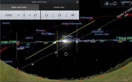
equinox occurred at that point. This conjunction occurred in the year 3101 BCE
in the Gregorian calendar when Kṛṣṇa, who is held as a divinity by Hindus left
his mortal coils. A new Era of Time called Kali Yuga started ticking from then
onwards which is being followed by all Hindus even now. This Era is well
attested in numerous inscriptions found throughout India. The conjunction at
that date can be simulated only in the settings of to and fro oscillation. It
is reproduced from Jhora software incorporated with Surya (Vedic) Siddhanta and
the ayanāmśa calculated on the basis of that.
Date: January 22, 3101 BCE (Gregorian), 4.00 pm, Ujjain, India
Sun
- 1 Ar 46' 21.85"
Moon
- 0 Ar 19' 41.43"
Mars
- 6 Ar 44' 59.48"
Mercury
- 28 Pi 42' 36.42"
Jupiter
- 27 Pi 52' 42.86"
Venus
- 28 Pi
37' 30.14"
Saturn
- 28 Pi 09' 01.54"
Rahu
- 28 Vi
29' 33.41"
Ketu
- 28 Pi 29' 33.41"

Fig
9: Super conjunction at 0˚ Sidereal Aries in 3101 BCE
The
X-axis (horizontal) is plotted along the zero degree of sidereal Aries where
three years are noted, of which the middle one (3101) is the year when the
Super conjunction occurred (heralding an Era called Kali Yuga which continues
to be used by the Hindus in India). Above the zero-degree line, the degrees of
Aries are noted in increasing order. Below the zero-degree line, the negative
numbers denote the degrees of the sign Pisces, based on the distance from the
zero degree of Aries. Below -30, Aquarius begins.
The
graph shows the congregation close to the zero point of Aries (red arrow).
Except Mars and the Moon all the other planetary paths in the previous and
succeeding years are as per the simulation, showing the steady march towards
the congregation point. Since the moon shifts more than twelve degrees a day,
the line is drawn from the data on the preceding and the succeeding days of the
congregation. Since Mars was away from the plotted extent of the graph in 3100
and 3102, its location ten days before and after the congregation was taken to
plot its path.
This
conjunction does not appear for the planetary positions obtained from modern
ephemeris. The corresponding date in the Julian calendar was 17th
February 3101 BCE. The graph plotted using the data of the Swiss ephemeris
incorporated in Jhora software and the corresponding tropical precession degree
of the day showed absence of Super conjunction. Only six out of eight planets
were closer to each other, not at the beginning of sidereal Aries, but in
Pisces (Fig 10)
Date:
February 17, 3101 BCE
(Julian), 4.00 pm, Ujjain, India
Sun
- 20 Pi 45' 44.91"
Moon
- 25 Pi 30' 12.50"
Mars
- 17 Pi 21' 26.77"
Mercury
- 5 Pi 33' 47.45"
Jupiter
- 4 Ar 06' 58.23"
Venus
- 3 Ar 23' 05.35"
Saturn
- 23 Aq 09' 11.14"
Rahu
- 13 Li
42' 10.88"
Ketu - 13 Ar 42' 10.88"

Fig 10: Absence of Super
conjunction for tropical settings
Major differences can be seen in the above simulation,
when compared with the previous graph on Fig 9. The Star dispo
The same date simulated in Stellarium software (Fig 11
for the corresponding date in Julian date with zero year in between CE and BCE)
reflects what is shown in Fig 10.
Fig
11: The planetary combination for the corresponding Julian date from Stellarium
simulator
The vernal equinox for this year is seen at
mid-Taurus, not at the beginning of Aries - a requisite for the begin-date of
Kali Yuga that is fulfilled in the Vedic setting of to and fro oscillation. The
ecliptic and the equator of J2000 is shown along with those of the year under consideration
(3101BCE). The dotted yellow line crossing the ecliptic is super-imposed on Fig
11 to mark the zero point of sidereal Aries. The equinox of the day was far
left, in Taurus. The equinox of today is marked to the right of the zero point
of sidereal Aries. The planetary
positions are the same as shown in Fig 10. They were spread across Pisces
(sidereal) and not seen closer to the zero point of sidereal Aries as seen in
Fig 9.
Ayanāmśa, likely cause for the
discrepancy
The causes for this discrepancy have to be found out
but the simulation becoming successful for Vedic settings of zero ayanāmśa seems
to imply that ayanāmśa does play a role in accurately finding out the planetary
longitudes.
A random check done by this writer by picking out one eclipse
in each century for a 1000-year period from 1800 CE to 800 CE showed that none
of them matched completely with the epigraphic data of these eclipses. We
cannot ignore the epigraphic data of an eclipse that comes with additional
details on the activities done at the time of eclipse because they are the real
time records of an eclipse. Two sample cases were written in detail in my book,
‘Mahabharata 3136 BCE’.[ii] Of these two, the lunar
eclipse on 16th November 951 CE in Julian calendar (21st
November in Gregorian calendar) got over before moon rise in India, but the
inscription says that the eclipse was seen in Gadag in Karnataka in South
India.
There also exists a research study by Vahia et al.,
showing nine periods of anomalous eclipses in the 1400-year period between 1800
CE and 400 CE when 17 eclipses, well documented in several inscriptions, find
no mention in the NASA data-base.[iii] NASA calculations
suggest that these eclipses should not have been visible in India, but there
are inscriptions from multiple locations for each of these eclipses.
In a more recent case of solar eclipse on 30th
June 1601 which was visible in Kottayam in South India for which there is an inscription
giving the calendar elements of the day such as the Kali Era number, year name,
the star transited by the moon at the time of the eclipse, the week day, and
the solar degree (22nd degree in Gemini in sidereal zodiac) besides
the location of Jupiter and Saturn in sidereal signs, the NASA data shows the
location of the Sun two degrees earlier than the location given in the
inscription. The moon also was in the previous star.
The data matches with the tithi being Amāvāsyā (No Moon) when the solar
eclipse took place, but shows the day to be two days behind. The sun needed to
travel two full degrees to reach the 22nd day of Mithuna māsa
(mentioned in the inscription), i.e., Gemini and also to reach the star
Punarvasu. Jupiter also needs to cover two degrees to be in Virgo as stipulated
in the inscription. The speed of the sun and Jupiter being very much different,
and both having the same difference of just 2° to reach the position mentioned
in the inscription, we realize that the mis-match of these positions was due to
the ayanāmśa value! An addition of 2˚ of ayanāmśa brought parity with the data
in the inscription.
The rate of ayanāmśa is not a constant, nor can it be standardized. The
current value of J2000 will not be valid in a couple of decades. In support of
this let me cite another issue currently faced by the Vedic society. The
locations of long-term planets such as Saturn, Jupiter, Rahu and Ketu
calculated on the basis of the traditional school known as Vākya which remained
non-updated for more than a century with reference to ayanāmśa correction, do
not match with the current data of transit of these planets. Particularly, in
the case of Saturn the retrogression period in the traditional school widely
deviates from the current data of its position. In addition to ayanāmśa factor,
there seems to be variance in the speed of the planet (including the earth) and
variations in the orbital path of the planets.
With all these issues, the surprising element is the ability to simulate
the Super Conjunction at zero-degree sidereal Aries. At the same time, it must
be stated that it is not possible to create such near perfect simulation for
locations other than zero-degree sidereal Aries (the mid-point of the path) in
the to and fro simulation.
The cause may be found with the varying rates of equinoctial movement in
other parts of the equinoctial path. The segmentation of the cycle into four
parts of equal length in degrees and time, was perhaps to do with the inability
to deduce a standard calculation for each degree of the path. This will be the
case if the path is not linear but inclined. Before going further into this,
let us visualize the model that is best suited to simulate the to and fro
motion of the equinox.
How can the equinox change direction?
To answer this, we must know what causes the
equinoctial shift? Is it caused by the axial precession of the earth or the
precession of the sun along with the entire solar system?
The current theory of science proposes that the earth
spins like a top such that its axis draws a precession circle in the sky for a
duration of 26,000 years. Every year the axis precesses at the rate of
approximately 50 arc seconds by which the equinox is seen to occur 20 minutes
earlier. The equinoctial sun (also known as tropical sun) is observed in the
backdrop of a distant star. By this theory the Sun at the vernal equinox can be
seen shifted by a degree every 72 years (at the current rate of precession).
Suppose we calculate the shift since the inception of the Gregorian calendar in
1582 CE, the vernal equinox must have slipped by 6 days. But olden records on
equinoctial date and the archaeo-astronomy of ancient structures show that
there is no shift of the equinoctial point on the ecliptic. It has always
occurred on 20th or 21st March – the difference of one
day caused by the adjustment of the leap year.
The observation of equinoctial sun passing through the
center of many olden megalithic structures such as the Stonehenge, Angkor Wat
and Mnajdra temples of Malta, to name a few, does indicate that the equinoctial
sun never shifts from the assigned location of the ecliptic. (Fig 12)

Fig 12: Structures
aligned with the equinox
If one or two structures are found aligned to the
equinox of today, we can ignore them as coincidences. But there are many
structures built in different time periods in the past found exactly aligned to
the equinox of today. The only plausible explanation for this phenomenon of
perfect alignment is that every point (or degree) on the ecliptic (earth’s orbit)
is aligned exactly with the sun such that we are looking at the same point in
the sky every year, year after year on any given day. It is for this reason the
Abu Simbel receives direct sun rays on specific days of the year. Several olden
temples of India receive the equinoctial or solstitial rays exactly on the days
of equinox and solstice even today. This conflict between archaeo-astronomy and
astronomy throws a new understanding that there is no change in the alignment
between the earth and the sun, but the change is with reference to the sun
(along with the entire solar system) shifting in the backdrop of outer space.[iv] (Fig 13)
The only logical explanation for the alignment of
olden structures to the equinox of today is shown in Fig 13. The earth-Sun alignment
remained the same, but only the background changed.[v]

Fig 13: Equinoctial shift
caused by the sun’s movement
It also shows that the earth’s axis doesn’t precess
like a spinning top. The entire solar system (sun) is precessing at present. Imagine
a running path in a circular disc and imagine the disc is also moving
independently in its path. The movement of the runner on the disc with respect
to the victory post in the disc does not change due to the movement of the
disc. The background scenario changes as the runner moves towards his goal-post
much like how the zodiacal signs change in a year, but the shift to a new
position of the disc is because the disc has moved further. By looking at the
disc with respect to a changed background, would the runner think that since because
he is running, the background had changed? This is similar to what the current
precession theory proposes.
Another example is a moving train. The moving train is
the sun and the passenger sitting inside is the earth. The background trees are
the stars. The trees seem to move because the train moves, not because the
passenger moves. In the same way the sun along with the solar system moves in
the backdrop of stars. That movement must be like how a serpent turns its body
while moving. Only in a serpentine movement, the equinox can appear to move to
and fro.

Fig 14: Serpentine movement
Imagine an ant sitting on a snake. It will witness
itself and the snake move hither and there as the snake keeps moving.
Similarly, the earth as a constant companion of the sun witnesses the Sun move
in one direction for some time and in another direction after that. This kind
of wavy path is a common feature of movement with any celestial body. Presently
it is found that the sun moves around the Milky way galaxy in a wavy path. The
to and fro theory suggests that within this wavy movement, the sun is wobbling across
space in a short wave length with the distance of 54˚ between a crest and a
trough traversed in 3600 years!

Fig 15: Wavy path of the Sun
causes to and fro movement of the equinox
The mechanism behind the equinoctial shift shown in
Fig 3 can be understood from the wavy path of the Sun shown in Fig 15. The
equinox can be observed to move between 27˚ Aries and 3˚ Pisces (27˚ to the
west of zero-degree sidereal Aries). They mark the two limits of the wave. Zero
sidereal Aries coinciding with the mid-point of the oscillation was chosen as
the beginning of the zodiac.
The wavy path of Sun ensures that an observer on earth
would not perceive the movement of the sun at a constant rate of displacement
from one year to another, though the Sun is moving at an almost constant rate. While
crossing the middle of the path, coinciding with 0˚ sidereal Aries, the Sun seems
to be at its average speed of equinoctial shift of 54 arc seconds at the rate
of 66.66 years as given in Fig 2. At every degree before and after that, slight
change at the rate of displacement is perceived, requiring the ancestral Vedic
society to calculate it every year. That they, who have given this ayanāmśa
concept, did not give the rate of displacement for other times in the path goes
to prove that this society had not gone through many rounds of this to and fro
movement to arrive at a formula for calculation for other times.
In my understanding, the awareness of this movement
and the observation of the same started only two rounds before, at a time
Polaris was the northern pole star in 12,101 BCE. The identification of a pole
star with Dhruva,[vi]
a real-life character, must have started at that time coinciding with the end
of Ice age. The observation had continued and newer revelations were gained by
the time of Rama and Agastya when Polaris was once again the pole star. They will
be disclosed later in this essay. With
the next cycle starting in the upcoming centuries, the scientific community of
the world can keep a constant track of the equinoctial shift for at least 3600
years to evolve a formula to calculate the constantly changing ayanāmśa in the
Sun’s path.
Evidence for the Sun having
entered the curvature of the path
With the ayanāmśa at the 25th degree now,
the Sun is seen at the verge of turning around at one end of the wavy path. In
view of the stipulation of the Vedic society to not recognize the slipping of
the winter solstice behind 0˚ Capricorn (so that winter solstice is always
observed on the day the Sun enter 0˚ Capricorn), it is deduced that the wave
limit through which the Sun is going now can be considered to be the trough of
the wave.
What can be expected to happen on the earth if the
earth turns around the curve along with the Sun? Have we started getting any
signs of the turning around?
Evidence 1: The change of
direction of rotation of the inner core
The recently reported information on the inner core of
the earth having paused for some time and starting the rotation in an opposite
direction to the direction of the spinning earth raises a feasibility of a
correlation with the earth having entered a curved path now.
To understand this, imagine a car that is moving
around a corner. When the car turns on one side, the inmates of the car will be
pushed to the other side due to centrifugal force. The same principle can cause
the inner core of the earth move in the opposite direction of the rotation of
the earth.
To understand the mechanism, let us look at the
composition of the earth. It has an outer crust upon which we live. The next
inner layer is filled with mantle. Beneath that there is a region of outer core
filled with molten material (liquid). Within that, a solid inner core of the
size of Pluto remains suspended in the liquid outer core.

Fig 16: Inner layers of the
earth
As the earth keeps rotating on one side (always in
anti-clockwise direction that makes the sun rise in the east), the liquid in
the outer core also rotates in the same direction (anti-clockwise). This causes
the free rotating inner core to rotate in anti-clockwise direction (the
direction of the earth’s rotation).
Once the earth starts turning around, the liquid in
the outer core inside the earth will be pushed to the opposite direction. Due
to the change of direction of the liquid, the freely rotating inner core will
be dragged initially by which it loses the regular speed of rotation. Slowly it
will come to a halt and then will begin the rotation along with the motion of
direction of the outer core (which has started rotating in clockwise direction)
which is the opposite of the direction of rotation of the earth.
In their paper, Mr. Yi Yang and Mr. Xiaodong Song, the scientists of Peking
University, observed that the ‘differential inner-core rotation has recently
paused’ but a ‘gradual turning-back of the inner core relative to the mantle’
is observed which seems to follow a seven-decade period of oscillation.[vii]

Fig 17: The changed rotational
direction of the inner core
It is difficult to rationalize this phenomenon with
our current knowledge of science. If the earth is going in a linear path (the
rotation around the Sun is only a visualization in a static model), this cannot
happen, but it is quite possible in a curved path as proposed by the Vedic
theory of to and fro oscillation of the equinox.

Fig 18: Probable theories for
the change of rotational direction
There are some who propose a periodical oscillation of
the rotational direction of the inner core ranging from 6 years to 70 years.[viii] But purely from a common-sense
perception, it can be said that there is a directional deviation in the earth’s
path – a kind of wobbling caused by the pull from two different directions –
from the Sun holding the earth by centripetal force and the centrifugal force
causing the earth to be dragged outward. As the earth (the solar system)
adjusts itself to maintain the curved path, there is bound to be scope for
fluctuations in the rotational direction of the inner core which is observed
only in the last few decades for which data is available.
Evidence 2: Change of
direction will impact the atmosphere including the ozone layer
Just as how the liquid inside the earth will respond
to the direction of the motion of the earth, the thick band of air surrounding
the earth will also behave differently when the rotating earth changes
direction by moving around a curve.
As a lay person, I imagine the wind-force felt by me
when a speeding car overtakes the car I am travelling. The wind-force will be
greater when a speeding car whizzes past me from an opposite direction.
Thinking of the earth swirling around a corner in its path (along with the
entire solar system), it appears that the atmosphere circulating on the surface
of the earth will encounter a reverse force, that is opposite to the direction
of the movement of the earth. As a result, anomalies in wind circulation
patterns can be detected in the period of movement of the earth negotiating a
curve.
Additionally, there is also a probability of the
turning path tilting a little from the original angle. This is applicable to
the entire plane of the solar system and not to the individual planets which
are all in equilibrium with each other and the sun. This is like a
Merry-go-Round ride having cups of seats fixed to the central axis. The cups (imagine
planets in their places) will revolve with a slight tilt / bend but their
distance from each other and alignment with the central axis (Sun) will not
change.
To cite another example, we can visualize the way an
air plane bends its body while it is turning.

Fig 19: A plane around a curve
(Pic from a web source)
The blue and red arrow lines in Fig 19 show the
direction of the competing centrifugal and centripetal forces respectively. The
resultant forward motion is shown by the green arrow mark. The plane itself
makes a tilt as it negotiates the curve. Once it has entered the straight path,
it regains the normal position.
This rationale when applied to the earth turning
around a curve (along with the solar system), will cause the earth to be tilted
(not detected by us). Though it is beyond my scope to speculate how this would change
the angle of solar radiation reaching the earth, the reported reduction in
ozone depletion raises a question whether the earth is experiencing a change in
the angle of tilt in its overall path along with the Sun.
One way to check this is to probe the causes for ozone
healing when it is accompanied with strong polar vortex. Though the ban on
ozone-depleting chemicals helps in reducing the ozone loss, it is also said the
strength of the polar vortex and warmer stratospheric temperatures reduce the
depletion rate.
Originally, the models showed no reduction in ozone
depletion until 2100, the year the model run ended.[ix] However, of late a
reduction in depletion is detected attributable to warmer stratospheric
temperatures. “It’s important to recognize that what we’re seeing this year is
due to warmer stratospheric temperatures,” said Paul Newman, chief scientist
for Earth sciences at NASA's Goddard Space Flight Center, in a statement. “It’s
not a sign that atmospheric ozone is suddenly on a fast track to recovery.” [x]
In the event of a turn-around of the sun causing a
tilt to the solar plane, a lay person like me is led to wonder whether the
temperature hike in the stratosphere in recent years was due to any changed
dynamics caused by the tilt. Across the solar system there are bound to appear
newer phenomena in terms of disturbance to polar vortex of other planets,
aurora sightings in other planets, tremors in other planets (like the first
Mars-quake recently detected) which might be connected with the tilting solar
system. Any unusual event such as the detached plasma material of the Sun swirling
around to reach the polar vortex of the Sun gives a different perspective when
seen in the prospect of the curving path of the Sun.[xi] (Fig 20)
Earlier in the year 2020, the earth rotated faster
than normal on a record number of 28 days since the data collection started in
1960. It was thought to have been caused by ‘variations in atmospheric
pressure, winds, ocean currents and the movement of the core’. [xii] The revelation offered
by the to and fro oscillation theory shows disturbance to all these factors
that have a bearing on the earth’s speed, atmospheric currents and global
climate.

Fig 20: Broken material from
northern prominence of the Sun circulating in Polar vortex
The extreme weather conditions witnessed since 2000 in
the form of heat waves, extreme winters, calamitous rains and unprecedented
floods around the world are all attributable to the disturbance in the wind
pattern circulating around the world and particularly at the poles. There also
exists the probability of shifting rain patterns and monsoon winds causing
record drought conditions in different parts of the world.
Notably such climatic factors caused the decline of
the Harappan civilization.[xiii] That period coincided
with the change of the equinoctial direction the last time, from forward to
precession mode. By 1300 BCE the precession movement had started as per the to
and fro theory. The drought conditions started 500 years before that when the Harappan
regions started experiencing shift in rain patterns that ultimately caused total
collapse of that civilization by 1300 BCE.
In the current times, the climatic anomalies started
from the 17th century with the onset of Little Ice Age. They will
continue for at least 500 years until the sun resumes a forward path. As per
the to and fro theory, three more centuries of extreme climatic conditions are
due before the equinox is seen to move forward.
Evidence 3: Change of
direction of the earth’s axis
It was earlier shown how the archaeo-astronomy of the
olden megalithic structures disprove the idea of precession of the earth’s
axis. The axis is fixed towards a particular direction, but it will be seen to
turn towards the opposite direction if the earth is turning around. Recently it
was reported that the axis has changed the direction from west to east. “Around
the year 2000, Earth's spin axis took an abrupt turn toward the east and is now
drifting almost twice as fast as before, at a rate of almost 7 inches (17
centimeters) a year. "It's no longer moving toward Hudson Bay, but instead
toward the British Isles," said Adhikari. "That's a massive
swing." Adhikari and Ivins set out to explain this unexpected change,”
reports a NASA study.[xiv]
The study also reported three causes for the change in
direction, namely, isostatic rebound of land forms formerly under ice sheets,
melting of the ice sheets and mantle convection. None thought about the
probability of the earth turning its direction. In the normal course, that is
how one would explain, but our conditioned thinking to continuous precession seems
to have closed our mind to think unconventionally about a conventional way of
movement of bodies.
For example, think of a car moving around a curve. Its
front wheels, until then parallel to the body of the car will turn towards the
direction of turn. This is followed by the entire car turning around. Once it
reaches the straight path, the wheels will gain their original orientation.
Imagine the axis of the earth as the wheel. It will be seen turning to the side
of the curve if the earth in moving in a curve.

Fig 21: Wheels of a car
turning to the direction of the curve
The change of direction of the axis can be explained in another way too. The earth behaves like a gyroscope in zero gravity which cannot change its orientation. Watch the video of European Space Agency on the spin of a gyroscope whose orientation changes only when the plane of rotation changes. The probability of a change (by a tilt) in the rotating plane of the earth (including the entire solar system) was already highlighted in Evidence 2.
Steady and altered orientation of gyroscope in zero
gravity - a demonstration
The earth spinning in zero gravity, will have its axis
pointing out to a fixed direction as it was since its birth. When the plane of
rotation of the earth tilts, the direction of orientation of the earth’s axis
can be seen to drift on one side. The earthlings can’t feel the tilt. No
satellite on space can detect the tilt because the entire set-up is tilting.
Only by the change of direction of axis which is supposed to remain oriented to
a fixed direction like a gyroscope, can we deduce that the earth is slowly
tilting as it is made to travel in a curve.
A remarkable feature on all the three issues we
discussed so far is that the events were triggered only from the year 2000 CE
onwards. The abrupt turn of the axis of the earth started only in 2000 CE. The
reversal of the direction of the inner core of the earth started only after
2009. The ozone healing process accompanied with strong polar vortex
(indicating air circulation dynamics) started only after 2000 CE. In the year
2000 CE, there was a rare congregation of six planets closer to the zero-degree
sideral Aries too!!
Date: April 14, 2000 CE
(Gregorian), 12 AM., Ujjain, India.
Sun - 0 Ar 17' 31.34"
Moon
- 28 Cn 50' 04.54"
Mars - 21 Ar 56' 45.34"
Mercury - 7 Pi 19' 28.52"
Jupiter - 18 Ar 16' 22.34"
Venus - 14 Pi 47' 57.95"
Saturn - 23 Ar 10' 49.62"
Rahu
- 5 Cn 43' 50.27"
Ketu
- 5 Cp 43' 50.27"
Fig
22 shows the location of six planets with the exception of the Moon and the
node, hovering closer to the beginning of sidereal Aries, when the Sun entered
sidereal Aries – the mid-point of the to and fro oscillation. (The horizontal 0
axis shows numbers 1 to 8 in the order of serial numbers for the planets in the
data-set)

Fig 22: Six planets near the
beginning of sidereal Aries on 14th April, 2000 CE
The corresponding date in Julian Day is simulated in
Stellarium simulator.

Fig 23: Six planets near
Tropical Aries, away from sidereal first point of the zodiac
The equinox of the day is shown in Fig 23. That marks
the beginning of Tropical Aries which is away from the beginning of sidereal
Aries which is 23 degrees to its left in Fig 11. In the terms of Vedic
astronomy, the congregation occurred near the beginning of sidereal Aries.
Evidence 4: Change in the rate
of displacement of solstices moving towards each other
The Tropic of Cancer and the Tropic of Capricorn mark
the two limits on the earth within which the Sun is seen to move. The Sun
cannot be seen overhead to the north and south of these two respectively. These
two limits are not found to be fixed, but seen to move towards each other.

Fig 24: The two Tropical
limits (solstices) moving towards each other
The reason for this movement is attributed to the
axial tilt of the earth changing its inclination or obliquity which is said to
be varying between 22.1 and 24.5 degrees. Today it is 23°26′10.6″ and
decreasing. Let us visualize how this movement appears if it is caused by the
earth’s axis tilting.
Fig 25 shows the earth in three positions. The axis of the earth cuts the equator (E) at right
angles, making the equator and the axis always separated by 90˚ (A in Fig 25).
If the axis tilts by, say, 23˚, the equator also tilts by 23˚as they always
remain perpendicular to each other. In
Fig 25-B this angle is marked as O. The corresponding position of the Tropic of
Cancer (S.S / Summer Solstice) and the Tropic of Capricorn (W.S / Winter Solstice)
are shown in B.

Fig 25: Movement of the
tropical limits in response to the changing tilt
Since the tilting angle is decreasing now, the
direction of the change of the axial tilt is shown accordingly in Fig C along
with the corresponding shift in S.S, W.S and E (Equator). All of them must move
northward. But what do we find now? The S.S and W.S are moving towards each
other! (Fig 24)
If the axis is tilting, the two will move towards the
same direction in tune with the direction of the shifting angle of tilt – and
not towards each other. It defies logic.
Moreover, the change in obliquity caused by the
ever-changing angle of the tilt of the earth’s axis will not cause the equinox
to occur on the same point of the ecliptic, which is what the current
scientific theory of precession says. But the fixed alignment of the ancient
monuments such as Stonehenge and Angkor Wat show that the equinox never changes
its location on the ecliptic.
Solstitial limits (of the Tropics) offer other
surprises too. The rate of movement of the two limits keeps changing over time.
This is known from the olden markers or monuments built on the location of the
Tropical limits in the past. Mexico alone is dotted with such monuments built
over 100 years. The earliest I could spot (on google search) was made in the
year 1891. (Fig 26). The website that gave the information that it was 5 km
north of the current limit of the Tropic of Cancer is not seen now. That
distance shows that the Tropics had moved at the rate of 38.75 meter per year,
when we take 2020 as the base year.

Fig 26: Monument in Mexico at
the location of Tropic of Cancer in 1891
At present the Tropical limits are moving at the rate
of 15 meters per year. At this rate, this monument (Fig 26) must have been
cited at 2 km north of Tropic of Cancer, not at 5 km. The current data of 15 meters
per year is obtained from 2005 onwards. Markers are erected at the Tropical
limit every year in the Mexican Highway (Fig 27).

Fig 27: The shift of the
Tropic of Cancer
What is inferred is that the speed of the solstitial
movement has come down. A further hunt for data for other years in the past led
me to two links, one on a monument built in the year 1908 which stated that the
Tropic of Cancer has shifted 1 km south of that monument now (Fig 28).[xv]

Fig 28: Monument at Tropic of
Cancer in 1908 in Mexico
Another link from a news magazine of India, Times of
India, dated June 29, 2005, gave an input about a monument at Jia-Yi in Taiwan
built in the same year 1908 shifted by 1.27 km in about 100 years.[xvi] This was stated in 2005,
three years short of 100 years.

Fig 29: Monument at Tropic of
Cancer in 1908 in Taiwan
The monuments built on the Tropic of Cancer in the
same year, anywhere on the earth will be at equal distance from the equator
because the Tropic of Cancer (or Capricorn) is parallel to the equator. When we
compare their location with the present date, the shift will be uniform. It
cannot be 1 km at one place and 1.27 km at another place. Moreover we are not
sure how many years were over when these observations were made – though in the
case of Taiwan, the date of the news report shows that it was less than 100
years. But by that year, the enumeration of the distance has started in Mexico
(Fig 27) which shows that the yearly shift was 15 meters. It is less for both
Fig 28 and Fig 29 which I am rejecting due to lack of data and exactness.
Taking up 1891 monument and the current rate, the
shift has reduced from 38.75 meters per year to 15 meters per year. Why is it
reducing? Was it moving at all times in the past? If so, why are we not seeing
such monuments in architecturally rich Mexican country? Why do such monuments
appear only in the last 100 to 150 years in Mexico?
More importantly, the question remains why the
Tropical limits are moving towards each other? By looking at things around us,
I can think of an illustration which is shown in Fig 30.

Fig 30: The edges come towards
each other when closer to the light source
Fig 29 shows two scenarios, A and B each with similar
light source but the surfaces receiving the light rays are at different
distances. The limits of the light rays are marked as SS and WS in Fig A, to
represent Summer Solstice and Winter Solstice respectively. E denotes
Equator.
Figure B shows the same scenario, but with the surface
closer to the light source than in Figure A. In that scenario, SS of Fig A
shifts to SS-1 and WS of Fig A shifts to WS-1. In other words, SS and WS move
towards each other when the distance between the surface they represent and the
light source reduces.
This analogy when applied to the movement of the two
Tropical limits towards each other, presumes that the light source (the Sun)
must be inching closer, but there is no evidence for it so far. The distance
between the earth and the Sun is within the observed or calculated range. The
tilting solar plane and the turn-around in the curve are the probable sources
for a change in the angle of light falling on the earth. This is only a crude
conjecture from me, but I have something to say about this movement based on two
allegorical stories recorded in Indic sources.
Nahusha’s Fall
There is a story of the Fall of Nahusha, a king who
lived before Rama’s period.[xvii] After he reached
heaven, he captured the throne of Indra, the God of celestials and caused the
Sapta rishis (Ursa Major) carry him in a palanquin. Sage Agastya (Canopus) was
also made to carry his chair. In due course, the sages could not move faster
which infuriated Nahusha. He kicked the sage Agastya by which he was cursed and
he fell down on the earth as a python!

Fig 31: Fall of Nahusha (Pic credit: Wikipedia)
After him, his son, Yayāti also travelled in the heavens but fell down. The places where they fell became pilgrim centres as per Mahābhārata. The place of Yayāti’s fall is part of ‘Jambu Mārga’ the solstitial belt across India – the belt of Tropic of Cancer! (Fig 32) Narmada River formed the lower or the southern limit of this belt while the northern limit is not known. But it should have been a small stretch of land from North to South as per the description of the Mahābhārata.[xviii]

Fig 32: “Jambu Mārga” - the
belt of Tropic of Cancer in India
The story seems to indicate certain events in Nature
related to the sky and the earth. By bringing in the Sapta rishis (Ursa Major)
as bearers of the palanquin, some movement is indicated. By having stated that
Nahusha kicked Sage Agastya urging him to move faster, we deduce that Agastya
was in the front. This arrangement seems to imply that the movement was from
North (indicated by Sapta rishis) towards South, where Agastya, the star
Canopus is seen. That movement started getting slower. The fall of Nahusha
seems to indicate the prospect of a complete standstill. His son who attempted
to move in the sky in the same way also fell down, thereby indicating once
again that the movement stopped.
Agastya stopping the
movement of the Vindhya Hills
There is yet another story seeming to convey the
movement of the Tropic of Cancer coming to a standstill. It involves the same
sage, Agastya. As per that story told by Rāma in Vālmīki Rāmāyana, Vindhya, the
mountain range located in the middle of India started growing high and hindered
the Sun. Agastya stopped its further growth.[xix] Agastya ordained that it must not grow further
till he returned from South.
This story is allegorical of the movement of the
Tropic of Cancer southward (as it is now). Figure 33 shows an illustration of a
hill (assume it to be the Vindhya range) across which the Tropic of Cancer is
passing.
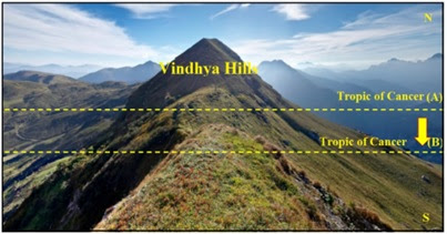
Fig 33: Shift of Tropic of
Cancer obstructs the Sun’s limit
The shift is shown from North (N) to South (S). Once
the Tropical limit started shifting southward from A to B, it appeared as
though the mountain was growing high. The Southward shift restricted the
tropical limits of direct Sun. The Sun which was supposed to go up to A was
stopped to go until then when the Tropic of Cancer shifted to B. This was
expressed as the Vindhya Mountain obstructing the path of the Sun. Agastya
stopped the Vindhya Mountain from obstructing further. This could mean that
there was no longer any shift in the Tropic of Cancer further southward.
Even the very etymological meaning of Agastya is one
who stopped the mountain. This story signals the movement of Tropic of Cancer
coming to a halt during his period. Both Rāma and Agastya were contemporaries. They
lived in the last round of the equinoctial cycle when Polaris (Dhruva star) was
the Pole star. Vālmīki Rāmāyana has a reference to Dhruva (Polaris) as the pole
star while Rāma was around.[xx]

Fig 34: Vindhya range and the
Tropic of Cancer in present times
Nahusha’s fall and Agastya subduing the Vindhya range
are two sides of the equinoctial event. The last time the Tropic of Cancer was
slowing down, the sages created a story of the fall of Nahusha. When it stopped
moving, Agastya’s story was made that it was he who stopped the mountain to
grow.
Now we are at the moment of a slowdown of the Tropic
of Cancer to 15 meters a year. The current speed will slow down to 14 meters
per year and reduce further. That will be the test of proof for the theory of
“Nahusha’s Fall”. Nahusha means python and he fell down as a python as per the
story. The reference to the python seems to be part of the equinoctial story
that found its way into iconography.
An engraving (Fig 35) from an unknown past is
preserved in a glass-case in Kūdalaɻagar temple in Madurai. The chariot of the
Sun with the zodiac around is shown in the middle. Two pythons, one on each
side, are obstructing the movement of the sun. By the direction of the
galloping horses, it is seen that the sun is moving towards the south as it is
now. Stopped by the python, it will turn northward. Once it reaches the limit
on that direction, the python again causes the chariot to turn around.

Fig 34: Sun God in his chariot
flanked with pythons on his two sides
Why should the chariot turn around?
The slowing down and the eventual stoppage reminds one
of how a superior planet (a planet beyond the orbit of the earth) is seen when
it begins retrogression or comes out of retrogression. When seen from the earth,
retrogression and reversal of retrogression of a superior planet make the
planet appear to go from forward to backward and from backward to forward
direction respectively. Before changing the direction, the planet will pass a
stage of no-motion when it will be seen static from the earth. This is shown in
Fig 36 for the path of Mars.

Fig 36: Process of
retrogression of a superior planet
Before it changes direction by retrogression, the
planet (Mars) will be seen from the earth as slowing down and stopping for a
while. That point is shown by an arrow. After a brief motionless period, it
would start again but in the opposite direction.
The same will be witnessed with the equinoctial sun
and the solstitial limits slowing down and not moving at all for some time
because of the change of direction. When this is going on, the earth will be actually
moving around the curve along with the Sun. Since the earth travels along with
the Sun, the observer from the earth will only see a static Sun (in equinoctial
terms) for sometime before it is seen to move in the opposite direction.
The earth will be like the ant on the serpent (Fig 14)
sitting at the exact point of curvature of the serpent’s body from where the
ant cannot perceive the movement of the serpent forward or backward and only in
stagnation mode. That is similar to the location shown by the arrow mark in the
above Fig 36.
Once the Sun starts moving towards the forward path,
the equinox and the solstitial limits will start moving. The equinox will be
seen to move forward. The solstices will be seen to move away from each other –
contrary to how they are moving now. The Tropic of Cancer which is seen to move
towards South now with reduced speed, will stop moving for some time and then
resume movement in the opposite direction – i.e., from South to North (Fig 37).

Fig 37: The movement of the
solstices away from each other
These events seem to follow a 3600-year cycle in
tandem with the to and fro theory. The
last time (c.1300 BCE) it caused the decline of the Harappan civilization and
the loss of River Saraswati due to tectonic displacement. Such disturbances
must have occurred at different places globally. In the previous before last
(c.4900 BCE), the 1st Tamil Sangam regions in the India Ocean were
lost to the seas. Perhaps the Sunda shelf erupted with volcanism. Mascarene
plateau also went under water signaling subsidence in that part of the earth.
Now crossing the same point in sky as was in Nahusha’s
time, we have started witnessing the inner core changing direction, the earth’s
axis changing direction and the solstitial limits slowing down. The churning of
the magma (symbolically known as the Churning of the Milky Ocean) seems to have
started as the earth turns around with the sun in its path. Not only the liquid
of the Outer core, the mantle under the crust is also disturbed, causing the
‘sloshing of the magma’ which will result in a series of volcanic eruptions,
tectonic movements, subductions and submergences.[xxi]
Ultimately, the stagnation of the solstitial movement
within a century or two can be expected as “down-to-earth” evidence for the to
and fro oscillation theory of equinoxes of the Vedic sages. The Vedic sages did
not use telescopes or gadgets to propose this theory. They just watched the
earth, the shadow on the earth and the movement of sunlight on the earth to
have offered this theory and its application in day-to-day life. We have yet to
catch up with them…
*****
Update on 10th July, 2023
The entire disk of the solar system is tilted by 6 degrees, it is reported in Physics-Astronomy.com
The cause is thought to be the un-discovered 9th planet of the solar system. Its time we deviate from the beaten track and do out-of the box thinking. Whatever happens to the solar system can be traced to the way the sun behaves and not with a planet within a solar system.
This tilt is something I expected in the model of the winding path of the Sun. I have shown in the article how the tilt is possible in the current times as the sun is moving around a curve.
https://www.physics-astronomy.com/solar-system-titled-planet-9/
Our Solar System Is Tilted And A
Mysterious ‘Hidden’ Planet 9 Is To Be Blamed
By
Editor
December 1, 2022
The mysterious tilt of our Solar System may be
explained by the gravitational influence of the elusive Planet 9, reshaping our
understanding of the cosmos.

The Enigma of the Tilted Solar System
For more than a century and a half, astronomers have
known that the Solar System is tilted. The sun rotates on an axis that isn’t
quite perpendicular to the orbits of Earth and the other major planets. This
peculiar tilt has been a subject of intrigue and speculation among scientists
for decades. The planets, including Earth, orbit the sun in a relatively flat
plane, but the sun’s axis of rotation is about 6 degrees off from perpendicular
to that plane.
The Hypothesis of Planet 9
In recent years, a new hypothesis has emerged that may
explain this mysterious tilt. A group of planetary scientists at Caltech in
Pasadena, California, proposed the existence of a hypothetical Planet 9, a
massive and as-yet-unseen planet at the outer edges of the Solar System. This
Planet 9 is thought to be about 10 times bigger than Earth and about 500 times
farther from the sun. Its orbit is believed to be inclined at an angle of about
30 degrees from the other planets’ orbital plane.

Solar System Titled Planet 9
The Influence of Planet 9
This cockeyed orbit of Planet 9 means that its
gravitational forces have been tugging on the other planets in a way that has
gradually caused their orbital plane to shift. “Because Planet Nine is so
massive and has an orbit tilted compared to the other planets, the solar system
has no choice but to slowly twist out of alignment,” says Elizabeth Bailey, a
graduate student at Caltech. This influence of Planet 9 could be the reason for
the observed tilt in our Solar System.
The Tilted Solar System: A New Perspective
Interestingly, the sun’s tilt doesn’t mean that the
sun itself is off-kilter. Instead, it’s the planetary orbits that are being
tilted by Planet Nine. “So Planet Nine has tilted the entire disk of the solar
system by 6 degrees and because we live on that disk…to us it looks like the
sun is tilted, but it’s actually the other way around,” explains Konstantin
Batygin, an assistant professor of planetary science at Caltech.
The Mystery of Planet 9’s Orbit
While the Planet 9 hypothesis provides a plausible
explanation for the sun’s apparent tilt, it also raises new questions. For
instance, what explains Planet Nine’s bizarre orbit? Some scientists suggest
that early in the solar system’s history, gravitational forces from a star not
far from the sun pulled Planet Nine from the orbital plane that until then it
had shared with the other planets.
The Search for Planet 9
Despite the compelling arguments for its existence,
Planet 9 remains a hypothesis. It has not been directly observed, and its
existence is inferred based on its gravitational effects. However, several
groups of astronomers are currently searching for Planet Nine using some of the
world’s biggest telescopes. The discovery of Planet 9 would not only confirm
its existence but also provide a testable explanation for the otherwise
mysterious spin-orbit misalignment of the Solar System.
Planet 9: A Key to Understanding Our
Tilted Solar System
The existence of Planet 9 offers a fascinating
possibility to explain the tilt of our Solar System. If confirmed, it would
provide a significant piece of the puzzle in our understanding of the Solar
System’s formation and evolution. As we continue to explore the outer reaches
of our Solar System and beyond, the search for Planet 9 and the understanding of
our tilted Solar System represents one of the most exciting frontiers in
astronomy. The quest for Planet 9 is not just about finding a new planet; it’s
about deepening our understanding of our Solar System and our place within it.
The Impact of Planet 9 on the Solar System
The gravitational influence of Planet 9 is not limited
to causing the tilt of the Solar System. Its presence could also explain some
of the erratic movements of icy worlds in the outer Solar System. The
gravitational effects of this hypothetical planet could be responsible for the
unusual orbits of some trans-Neptunian objects. These distant objects in the
outer Solar System have orbits that are strangely aligned, a phenomenon that is
difficult to explain without the presence of a massive, distant influencer like
Planet 9.
The Origin of Planet 9
One of the intriguing aspects of Planet 9 is its
potential origin. Some researchers propose that Planet 9 could be an exoplanet,
a planet that formed around a different star and was later captured by our Sun.
This theory suggests that early in the history of our Solar System, the Sun may
have stolen Planet 9 from its original star during a close encounter. This
could explain the planet’s large size, its distant and eccentric orbit, and its
significant inclination compared to the plane of the Solar System.
The Challenges in the Search for Planet 9
The search for Planet 9 is fraught with challenges.
Its predicted location is incredibly distant, far beyond the orbit of Neptune,
the furthest known planet in our Solar System. At such distances, a planet,
even one as large as Planet 9, would appear incredibly faint and would move
very slowly across the sky, making it difficult to detect with current
telescopes. Despite these challenges, astronomers are optimistic, employing
advanced observation techniques and leveraging the power of the world’s most
sophisticated telescopes in the search for this elusive planet.
The Implications of Discovering Planet 9
The discovery of Planet 9 would have profound
implications for our understanding of our Solar System. It would not only solve
the mystery of the Solar System’s tilt but also provide insights into the
dynamics and evolution of the outer Solar System. Furthermore, if Planet 9
turns out to be a captured exoplanet, it would provide a unique opportunity to
study an exoplanet up close, potentially offering valuable insights into
planetary formation and evolution processes in other star systems.
Conclusion: The Enigma of the Tilted Solar
System and the Quest for Planet 9
The enigma of our tilted Solar System and the quest for
Planet 9 exemplify the spirit of scientific exploration and discovery. As we
continue to probe the outer reaches of our Solar System, we are not just
mapping distant worlds and looking for new planets. We are also seeking to
answer fundamental questions about the nature of our Solar System and its place
in the cosmos. Whether or not Planet 9 exists, the search for it is already
enhancing our understanding of the universe and our place within it.
***
Update on 23rd April, 2024.
Antarctica is warming up such that it's melt water is going to raise the global sea level by 3.4 m and dip the temperature in Europe by 9°F in a decade.
Read Here
Update on 26th May, 2024
Between May 10th and 12th of 2024, vibrant Aurora Borealis was witnessed till 26 degrees North and South abnormally. Normally they appear for around 3 to 6 degrees near the poles. During excess solar winds in solar maxima period they were visible till 36 degrees, But this time they were visible in far lower latitudes that it was even visible in Ladakh in India. NASA declared that this was the highest in the past 500 years without giving any reference for this statement. (Read here )
Pitch angle is the mechanism of how far the Aurora is seen. This is the angle between the direction of motion of the solar wind and the local magnetic field around the earth. This angle of the solar wind should have been more or tilted to interact with a huge part of the magnetosphere enveloping the earth.
This is can be the result of a tilting sun in the process of sending out its flames. Imagine a candle moving in a linear path and in a circular path. In the linear path, the flame would not shake much, but if the candle is turned around, its flame will stretch on towards one side. That has happened with the sun now. As it is in the process of turning now, the solar winds and flames created by the maxima phase are unleashed on one side severely. That is how they could reach through larger part of the magnetosphere.
This has also pushed the magnetic pole towards eastward in Siberia at the rate of 55 km in a year compared to 16 km per year in the past. The eastward movement also is in concurrence with the turn towards east. NASA expects a flipflop of the poles, but I don't think so because this seems to be the result of turning around and once the forward path is reached, everything will stabilize. (NASA article here .

Update on 27th May 2024.

[i] The basic unit of the Catur Maha Yuga is 432,000 years. This is calculated on the basis of the number of revolutions of the nine ‘graha-s’, roughly translated as planets that include Sun, Moon, Mercury, Venus, Mars, Jupiter, Saturn, Rahu and Ketu – the last two being the ascending and descending nodes of the moon. The revolutionary periods of these planets are calculated from geo-centric observation that include the retrogression periods of these planets. The LCM of all the revolutions, if they started together at 0° Aries gives the period 432,000 years. This is the duration of the current Era known as Kali Yuga that started on 3101 BCE when all the planets except Rahu congregated at 0° Aries. A Catur Maha Yuga contains 10 such congregations, covering 4,320,000 years.
[ii] Saranathan. Jayasree, Nov 2021, “Mahabharata 3136 BCE: Validation of the Traditional Date” https://www.amazon.com/dp/B09LS1WZ4X
[iii] Vahia et al., “Ancient eclipses and long-term drifts in the Earth - Moon system” Current Science. 105. https://www.researchgate.net/publication/253646240_Ancient_eclipses_and_long-term_drifts_in_the_Earth_-_Moon_system
[iv] Saranathan.
Jayasree, March 21, 2022, “ Conflict between Archaeo-astronomy and Astronomy
reveals new understanding of the Equinoxes”
[v] Saranathan. Jayasree, “No axial precession of the earth proven by archeoastronomy of ancient monuments” https://www.academia.edu/44178992/No_axial_precession_of_the_earth_proven_by_Archaeoastronomy_of_ancient_monuments
[vii] Yang, Y., Song, X. Author Correction: Multidecadal variation of the Earth’s inner-core rotation. Nat. Geosci. (2023). https://doi.org/10.1038/s41561-023-01136-z
[viii] https://phys.org/news/2023-01-earth-core.html#:~:text=Deep%20below%20the%20surface%2C%20the%20Earth%27s%20inner%20core,rotating%20slower%20than%20it%2C%20research%20suggested%20on%20Monday.
[x] https://www.usatoday.com/story/news/nation/2019/10/21/ozone-hole-above-antarctica-shrinks-smallest-size-record/4053468002/
[xi] https://www.forbes.com/sites/jamiecartereurope/2023/02/11/did-a-chunk-of-the-sun-really-just-break-off-the-truth-behind-the-headlines/?sh=140b9af47bfa
[xvi] https://timesofindia.indiatimes.com/india/Sliding-Tropic-of-Cancer-means-harsher-climate/articleshow/1154992.cms
[xviii] Mahābhārata: 3-82 https://www.sacred-texts.com/hin/m03/m03082.htm
[xix] Vālmīki Rāmāyana – 3-11-85 http://valmikiramayan.net/utf8/aranya/sarga11/aranya_11_frame.htm
[xx] Vālmīki Rāmāyana – 6-4-49
[xxi] Namiki et al,
“Sloshing of a bubbly magma reservoir as a mechanism of
triggered
eruptions” http://www.volcanotectonics.de/reprints/Namiki_sloshing_JVGR_2016.pdf


